Four Corners, 2013
START/FINISH (Arizona)
HOME :
| The Beginning: | |
| After Death Valley we headed to Arizona for the actual start of the "Four Corner's 2013" tour. The name " four corners" refers to the point where four states - Arizona, Utah, Colorado, and New Mexico meet. - The "Four Corners" Monument (picture on the right) a true tourist trap. Scientists are still arguing if this is actually the true spot, but as far as we were concerned, we didn't care. For our purposes, a better description of the "Four Corners" territory can be found in the map of the Navajo Nation below which |  |
 |
is about the size of West-Virginia and comprises significant parts of these states, other tribes have smaller reservations adjacent to the Navajo nation or, in the case of the Hopis, inside its territory. Consequently, good size parts of these four states are referred to as "Indian country" and that is what we were interested in. The Navajos are the largest still existing tribe of "First People" in the US and are the only one to have a large enough population and territory to be able to have a reasonable government, school system, even a college. AAA even issues an "Indian Country" map which is invaluable for driving on the "Rez", although one needs to understand that many roads on the Rez are only navigable with trucks or SUVs, definitely NOT with my S4 which was built for speed and curves, not dirt tracks. |
Essentially, the area is a desert filled with pituresque red rocks and was considered uninteresting by the white settlers and prospectors. Until they found and needed the uranium. However, before we headed to the desert, we stopped in Winslow, Arizona on Route 66. While there is precious little to see these days of the famous "mother road", ther is a commemorative marker on "the corner..." commemorated in theEagles song "take it easy". |
|||||
 |
 |
 |
|||
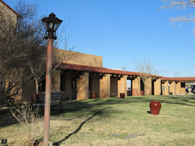 |
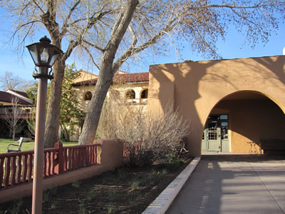
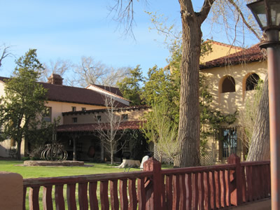
Actually, we were more interested in getting good food and sleep at La Posada - one of my favorite hotels. It began as a Harvey House (railroad hotel), designed by Mary Jane Coulter who not only designed the hotel, but pretty much everything that was (is) inside. After the passenger railroad era ended, the hotel was used as a railroad office and deteriorated badly, until it was rescued and restored to glory by an artist - Tina Mion. La Posada an interesting hotel, e.g., each room is individually furnished, | 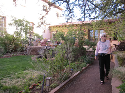 |
|||
| but it includes a gallery of Tina Mion's very interesting pictures, including reproductions of some rather famous ones that are in important museums. There is also an chance that I get to pet Ms Dion's parti-colored standard poodles. To top it off, La Posada has a very good restaurant where I like to eat Piki bread from Second Mesa (Hopi) and other regional specialties. The pictures above show La Posada and its gardens from various aspects. we wished we could have spent more time, but it was time to head east toward Santa Fe, New Mexico. But first |  |
||||
| we made a detour off the interstate to visit the Petrified Forest and Painted Desert National Park | |||||
|
|
|||||
| Trail's End: | |||||
| Having fled the mob scene at Grand Canyon village, we had enough time that we did not have to drive directly to Kingman, AZ (our final stop before ther return home). Instead we enjoyed a leisurly drive via Sedona, visited Montezuma Castle and Tuzigoot, National Monuments and finally reached Kingman after one more chance to put the Audi through its paces on the pass road through the Black Hills behind the former mining town of Jerome. It was an excellent decision. | |||||
 |
 |
 |
|||
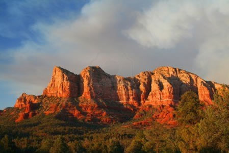
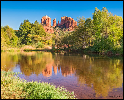
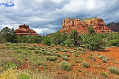
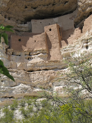
| The red rocks are always red rocks, but miraculously, they are different every time! Sedona is a small but famous resort town beloved by "New Agers". It is surrounded by spectacular scenery, as can be seen in the above pictures. The scenery is truly stunning, especially because there is sufficient water in the desert to permit the growth of natural vegetation. However, Sedona also has a number of golf courses that are kept green through sprinklers powered by water from the Colorado, which helps fill the towns hotels. While we did not have time (or interest) in playing golf and are not enamored of some of the esoteric psychic healers that abound here, but we admired the scenery during the drive to Montezuma's Castle The so-called castle - on the pictures below is one of the best preserved ruins in the four corners area. The building dates to the 12th |  |
||||
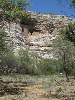 |
century. It is assumed that it was tucked into the cliffs for protective purposes. Probably due drying up of springs, the Sinagua Indiands abandoned it after brief occupation. |
 |
|||
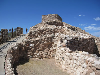
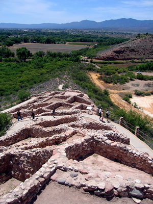
Tuzigoot National Monument was our next stop. It was occupied from the 12th to the 14th century by the Sinaguas. Again there are only assumptions, not certainty to explain it' abandonment. |
|
It looks like a lovely little lake across from Tuzigoot, but actually it is a tailing pit left over from Jerome's copper mining days |
|||
|
|||||
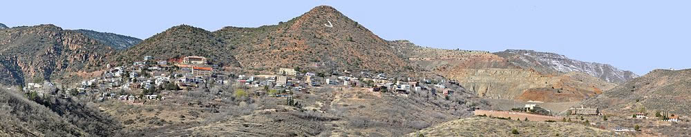
| A panoramic view of the town of Jerome - in the background the Black Hills. To cross them we had the pleasure of driving on an impressive pass road where 40 mph seemd like a reasonable speed even to me! | |||||
|
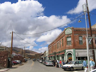
View of Jerome's main street |
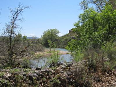
The site of Jerome, nestled into the Black Hills as seen above, was already known and extensively mined by the Indians for a variety of minerals - copper, gold, silver, and turquois. As white settlers and prsopectors discovered its riches, the indians were forcibly removed, as was common throughout the area. As was typical for the time, a rather sizeable settlement sprang up as excavation began. In its heyday Jerome had 15,000 inhabitants. However, as is also typical for Western boomtowns, as soon as the mines had played out, the towns' population shrank to a low of 50 people. Today | 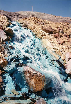 Stream tainted by copper tailings |
|||
| Jerome has about 400 residents who attempt to live off tourism. When we drove through we were surrounded by hundreds of Harley fans who apparently had a meet in the town. To our not unalloyed joy they would accompany us the next day from Kingman to Los Angeles to give us the opportunity to get used to serious traffic again. | |||||

